Tikal National Park
Ancient sprawling city complex remains set amid rich plant and animal life


Country: Guatemala | Type: Mixed | Theme: Archaeological
Introduction to Tikal National Park
Tikal is one of the largest urban centers and archaeological sites of the pre-Columbian Maya. Located in the department of Peten in northern Guatemala the site is located within Tikal National Park and was named a UNESCO World Heritage Site in 1979. Tikal received its name shortly after being discovered sometime in the 1840s, but the ancient name for the city is Yax Mutul.
Tikal became one of few powerful and important urban centers in the ancient Maya civilization. There are structures on site that date as far back as the 4th century BC but Tikal was at its most important in the Classic Period from 200 to 900 AD at which time the city was the dominant force in the Maya region militarily, economically and politically while having interaction with other Mesoamerica regions such a Teotihuacan in what is now neighboring Mexico. After the Late Classic Period ended there were no new constructions of importance at Tikal and evidence shows that many of the palaces were burned. These events transpired with the gradual decline in population and finally its abandonment in the latter part of the 10th century.
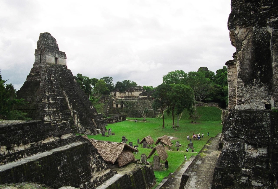
Tikal National Park covers 550 sq. kms and is the Petén’s most famous attraction. Within the 16 sq. kms that contain the ruins of this ancient Maya city. Over 3,000 structures thus far have been uncovered, including temples, palaces, ball courts and a sauna. Visitors to Tikal stroll along trails through protected jungle from one building complex to another. Toucans, monkeys, coatis, Ocellated Turkeys, trogons, motmots and many other tropical animals are commonly sighted along the trails.
The first sign of Maya at Tikal was in the 5th century BC. The city underwent a golden age of art written language and architecture in the Classic period of Maya history, from 200 to 900 AD, then mysteriously declined swiftly and the exact reason remains a mystery today. Most of the structures and stelae seen at Tikal today date from the Classic period.
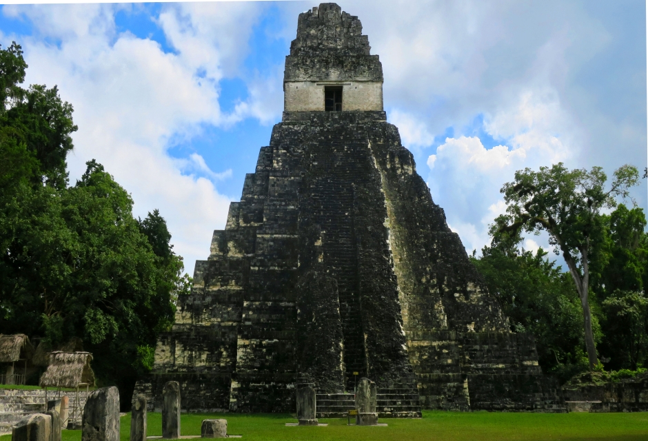
At Great Plaza, at one time the heart of the complex is the Temple of the Great Jaguar and Temple 2 along with a number of altars and stelae. Nearby Temple 4, the tallest off all structures the Maya built, towers 65 meters high, and be viewed above the forest canopy from miles away. The Great Pyramid of the Lost World, built around the fifth century AD, is a great spot for visitors to watch the to feed toucans and watch the sun set.
Visitor facilities at Tikal National Park include hotels, restaurants, a crafts market and two museums. The ceramics museum includes a replica of the tomb of Tikal ruler Ah Cacao, discovered under the Great Jaguar Temple. There are many beautiful ceramics on display, as well as incised bones, one of which has delicate scene of animal gods traveling in a canoe. Tikal’s other museum contains an exhibition of photos covering the exploration and excavation of Tikal, and a large collection of stelae and altars. Visitors should try to spend at least two days to fully appreciate this magnificent city and its forest setting. As more and more of Tikal gets excavated more becomes understood about Tikal’s history.
A major population and cultural center of the Maya civilization Tikal’s architectural dates around the 4th century BC and but reached its peak between 200 to 900 AD during the Classic Period. According to some the site was the dominant player of the Maya region but it is debated whether or not they ever had relationships with the indigenous population.
Evidence shows they were conquered by Teotihuacan around the 4th century AD. Tikal was unique in it did not have any water source other than rainwater. They stored the rain water in underground facilities called chultuns.
The city prospered with intense agricultural techniques which were much more advanced than originally theorized. Tikal was vulnerable to drought because of not having a water source besides annual rainfall and that is now thought to be one of the reasons for its collapse.
You can reach Tikal via air or land. Daily flights leave Guatemala City for Flores in Peten. The flight is less than an hour and once in Flores you can rent a car and drive to the Park, take a tour from one of the many tour operators at the airport or through your hotel you can also visit the park. The park is only about 30 miles from Flores and the road to the Park from Flores is in very good shape. There are also daily flights that leave Belize City that fly direct to Flores as well.
By Car:
The approximate travel time by car from Guatemala City to Tikal National Park is around 6 hours, covering a distance of approximately 350 km (217 miles). However, this can vary depending on factors such as road conditions, traffic, and detours. It’s always a good idea to check the current road conditions and plan your journey accordingly.
Key Facts
Inscribed:1979
Nearest City:Flores
Province:El Peten
Coordinates: Lat: 17.2220, Long: -89.6236
Accessibility:Moderate
Services:Adequate
Highlights
- 16 square kilometers, including more than 3000 structures
- Preserved area of National Park is 570 square kilometers
- 33 rulers over an 800 year span
- Royal palaces, residences and administrative buildings
- Palaces and inscribed stone monuments.
- Nine twin pyramid complexes
Find a Tour
Like to visit? Fill out this form and reliable local hospitality companies will contact you to discuss your ideas.