Rice Terraces of the Philippines
The unforgettable spectacle of vast rice terraces


Country: Philippines | Type: Cultural | Theme: Agriculture, Cultural Landscape
Introduction to Rice Terraces of the Philippine Cordilleras
The Rice Terraces of the Philippine Cordilleras have been etched into the curves of the mountains for 2,000 years in Ifugao. The knowledge of how to maintain these terraces is past down from generation to generation. Therefore, a careful balance is maintained between social and sacred traditions and the environment. This area is notable for its unique blend of economic, political, physical, socio-cultural and religious aspects of life, which is reflected in the beautiful landscape. Life on the terraces has managed to resist and overcome numerous obstacles posed by rapid worldwide modernization since ancient times. In fact, archaeological findings suggest that the farming technique used on the terraces has been mostly unaltered over its 2,000 year existence. The nature and limitations of the land is reflected in this terraced farming style which has exerted a strong influence on the local inhabitant’s social, cultural and economic context. Also in the area is a sacred grove of trees, private forests surrounding the terraces, and local villages. The locals, called Ifugao, have shown a mastery of terrace engineering and watershed ecology through their intricate farming system using the swidden farms, terrace ponds, and private forests or muyongs.
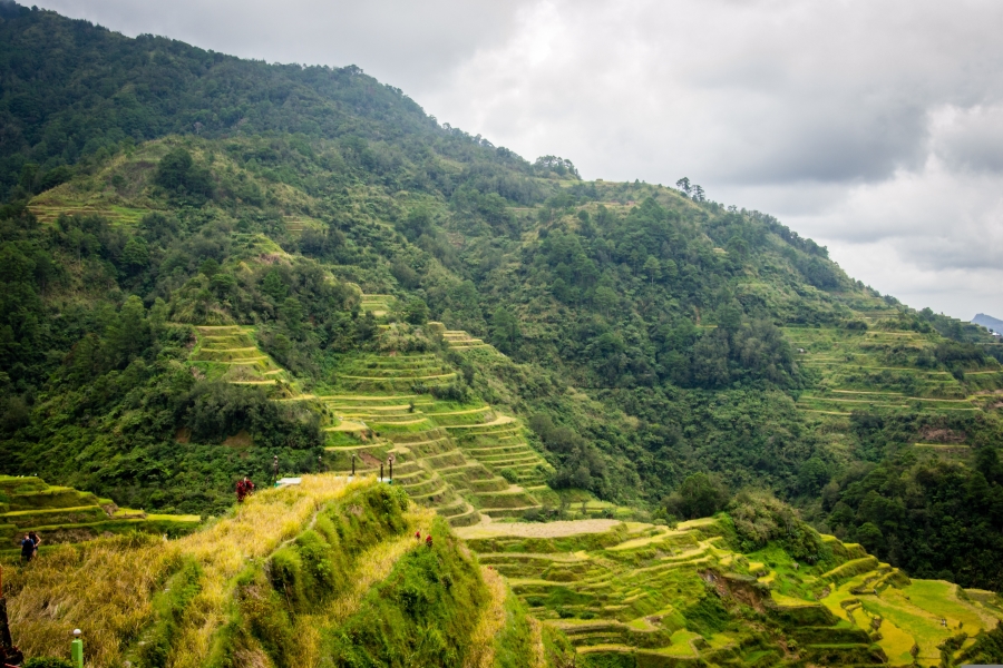
These terraced rice fields span a land area of 20,000 square kilometers and range in altitudes of 700 to 1500 meters above sea-level. They can be found in Abra, Ifugao, Kalinga-Apayo, Benguet, and Mountain provinces. The density of the local population in the area is about 100-250 persons per square kilometer. The area that was nominated as part of the UNESCO World Heritage List includes the best-conserved areas that span four clusters of terraces. Characteristic of each cluster is a buffer ring consisting of terraces, village, muyong, and a holy grove. The Philippine Cordillera rice fields are different among the numerous other rice field systems in Asia due to their steeper slopes and greater altitude. In fact, in Bali the slopes only reach a maximum of 40 degrees while the Philippine terraces reach a maximum of 70 degrees. Therefore, the indigenous farmers of the Cordilleras use a unique type of rice that must germinate at freezing temperatures and grows up to a meter in height. The panicles, a branched cluster of flowers, do not shatter in order to be conducive for harvesting on steep slopes that do not allow the use of machinery or animals to assist in the collecting the rice.
There is a careful and meticulous construction pattern to the rice terraces that can be observed. First, stones for marking are placed on a hollow and curved sloped with a heavy, broken-up gravel fill backing, which is placed into incisions in the natural mountain slope in order to avoid slippage down the mountain. Next, the level of the fill rises in altitude as each dry-stone walling course is appended. In addition, conduits for draining are constructed underground. Finally, as the fill’s level comes up to less than a meter of the preferred height, a strip of densely compressed earth is put over the gravel filling. On average, the stone walls are approximately 2 meters in height but can be up to 6 meters tall.
Part of the aesthetic appeal of the terraces is that they follow the contours of the mountain as they blanket over it. The muyong, or private woods, reach to the peak of the mountains above the rice terraces. Just like the terraces, these forests are carefully taken care of per ancient traditional practices of the tribes. As a result, a complete and beautifully functioning ecosystem is in place that provides water to each terrace down the slope with no field left wanting. A stream located at the base of the valley receives the water drainage via an intricate system of channels, bamboo pipes and sluices.
The hamlets or villages are connected with their own section of rice terraces and are mostly single-family abodes. The dwellings actually reflect the villager’s perspective of their mountain surroundings. Their wooden single-room homes are covered by steep roofs in the shape of a pyramid. The branches of a single family all reside in clusters with the sacred rice fields as the focal point of their village. There are also carved wooden gods in granary houses, called bui-oi, and a storage basket where consecrated sacrificial portions from every ceremonial rite of an agricultural nature is stored. The sacred hill is a short span away from the homes and is identified by its holy betel tree grove surrounding the abode of the holy men, or mumbaki, who perform the traditional rites of the village.
Lorem ipsum dolor sit amet, consectetur adipiscing elit. Ut elit tellus, luctus nec ullamcorper mattis, pulvinar dapibus leo.
Key Facts
Inscribed:1995
Nearest City:Solano
Province:Ifugao
Coordinates: Lat: 16.93389, Long: 121.13667
Accessibility:Moderate
Services:Adequate
Highlights
- Spectacular mountain setting
- Ancient farming techniques
- Beautiful, rolling rice terraces following the contours of the mountain
- Intricate and self-sustaining ecosystem
- Traditional tribal hamlets
- Ifugao witch doctors or healers